Potsdamer Platz (German: [ˈpɔtsdamɐ plats] ( listen), literally Potsdam Square) is an important public square and traffic intersection in the centre of Berlin, Germany, lying about 1 km (1,100 yd) south of the Brandenburg Gate and the Reichstag (German Parliament Building), and close to the southeast corner of the Tiergarten park. It is named after the city of Potsdam, some 25 km (16 mi) to the south west, and marks the point where the old road from Potsdam passed through the city wall of Berlin at the Potsdam Gate. After developing within the space of little over a century from an intersection of rural thoroughfares into the most bustling traffic intersection in Europe, it was totally laid waste during World War II and then left desolate during the Cold War era when the Berlin Wall bisected its former location. Since German reunification, Potsdamer Platz has been the site of major redevelopment projects.
Historical background
Potsdamer Platz began as a trading post where several country roads converged just outside Berlin's old customs wall. The history of Potsdamer Platz can probably be traced back to 29 October 1685, when the Tolerance Edict of Potsdam was signed, whereby Frederick William, Elector of Brandenburg-Prussia from 1640 to 1688, allowed large numbers of religious refugees, including Jews from Austria and Huguenots expelled from France, to settle on his territory. A key motivation behind the Edict was so the Elector could encourage the rapid repopulation, restabilising and economic recovery of his kingdom, following the ravages of the Thirty Years' War (1618–48). Altogether up to 15,000 Huguenots made new homes in the Brandenburg region, some 6,000 of these in its capital, Berlin (indeed, by 1700 and for a while afterwards as much as 20% of Berlin’s population was French-speaking). Two other things resulted from this huge influx. Firstly, Berlin’s medieval fortifications, recently rebuilt from 1658 to 1674 in the form of a Dutch-style star fort, on an enormous scale and at great expense (and similar to examples still in extant today in the Netherlands like Naarden and Bourtange), became virtually redundant overnight; and secondly, the already crowded city became even more congested.
Several new districts were founded around the city's perimeter, just outside the old fortifications. The largest of these was Friedrichstadt, just south west of the historic core of Berlin, begun in 1688 and named after new Elector Frederick William III, who later became King Frederick I of Prussia. Its street layout followed the Baroque-style grid pattern much favoured at the time, and was based on two main axes: Friedrichstrasse running north-south, and Leipziger Strasse running east-west. All the new suburbs were absorbed into Berlin around 1709-10. In 1721-3 a south-westwards expansion of Friedrichstadt was planned under the orders of King Frederick William I, and this was completed in 1732-4 by architect Johann Philipp Gerlach (1679–1748). In this expansion, a new north-south axis emerged: Wilhelmstrasse.
In 1735-7, after Friedrichstadt’s expansion was complete, a customs or excise wall, 17 km long and 4.2 m high, was erected around Berlin’s new perimeter. Consisting of a wooden palisade at first, it was later replaced with a brick and stone wall, pierced by 14 gates (later increased to 18), where roads entered the city. Here taxes were levied on goods passing through, chiefly meat and flour. The most prestigious gate was the Brandenburg Gate, for the important road from Brandenburg, but 1 km to the south was the entry point of another road that gained even greater significance.
This road had started out in the Middle Ages as a lane running out from Berlin to the hamlet of Schöneberg, but it had developed into part of a trading route running right across Europe from Paris to St. Petersburg via Aachen, Berlin and Königsberg. In 1660 the Elector Frederick William made it his route of choice to Potsdam, the location of his palace, which had recently been renovated. Starting in 1754 a daily stagecoach ran between Berlin and Potsdam, although the road was in poor shape. But in 1740 Frederick II had become King. Not a great lover of Berlin, he later built a new palace, the Sanssouci, at Potsdam in 1744-7, followed by the New Palace in 1763-9, so the road now had to be made fit for a King, plus all his courtiers and staff. After numerous other improvements, in 1791-3 this section was made into Prussia's first all-weather road. It later became Potsdamer Strasse; its point of entry into Berlin, where it passed through the customs wall, became the Potsdamer Tor (Potsdam Gate); once inside the gate Leipziger Strasse was its eastwards continuation, and Wilhelmstrasse was the first north-south thoroughfare that intersected with it. It was around this gate that Potsdamer Platz was to develop.
As a physical entity, Potsdamer Platz began as a few country roads and rough tracks fanning out from the Potsdam Gate. According to one old guide book, it was never a proper platz, but a five-cornered traffic knot on that old trading route across Europe. Just inside the gate was a large octagonal area, created at the time of Friedrichstadt's expansion in 1732-4 and bisected by Leipziger Strasse; this was one of several parade grounds for the thousands of soldiers garrisoned in Berlin at the height of the Kingdom of Prussia. Initially known appropriately as the Achteck (Octagon), on 15 September 1814 it was renamed Leipziger Platz after the site of Prussia's final decisive defeat of Napoleon Bonaparte at the Battle of Leipzig, 16–19 October 1813, which brought to an end the Wars of Liberation that had been going on since 1806. The Potsdam Gate itself was redesignated the Leipziger Tor (Leipzig Gate) around the same time, but reverted to its old name a few years later.
The history of Leipziger Platz has been inextricably linked with that of its neighbour almost since its creation (indeed, Potsdamer Platz and Leipziger Platz, being side by side, have frequently been regarded and discussed as being all one entity). Yet their respective stories have in many ways been very different. The future Potsdamer Platz was most definitely outside Berlin, and therefore not subject to the planning guidelines and constraints that would normally be expected in a city keen to show itself off as the capital of an empire. It grew very rapidly in a piecemeal and haphazard way, and came to epitomise wildness and excess in a manner that contributed much to its legendary status. Leipziger Platz however, was inside the city (and had a name almost a century before its neighbour did), and always had an orderly, disciplined look about it. After all, it had been planned and built all in one go by Johann Philipp Gerlach. One late 18th-century artistic depiction shows a range of buildings relentless in their uniformity. Indeed, this, together with the grid pattern of the streets, is what one would expect in Prussia’s chief garrison city. One writer of the time said that a stroll round Friedrichstadt was like walking round military barracks. In this respect the Potsdam Gate was a dividing line between two different worlds. It was not until later on that many of these buildings began to be replaced by edifices of architectural magnificence, around Leipziger Platz, along Leipziger Strasse which bisected it, and also Wilhelmstrasse. Eventually these streets became lined with important historical palaces and aristocratic mansions.
By this time however, Leipziger Platz was no longer a parade ground, and there had been much speculation about a possible complete redesign for the whole area. Back in 1797 had come the first of two proposed schemes that would have afforded the future Potsdamer Platz the appearance of a proper square. Under both schemes the old rural intersection just outside the Potsdam Gate, and the Octagon (Leipziger Platz) just inside, were to be joined together to create a long rectangular space, with a gargantuan edifice standing in the middle of it. The 1797 scheme came from the renowned Prussian architect Friedrich David Gilly (1772–1800), who proposed a monument to the former Prussian King, Friedrich II. Though containing some Egyptian and French neo-Classicist features, the design was basically a huge Greek temple in the Doric style, loosely modelled on the Parthenon in Athens, though raised up on an enormous geometric plinth and flanked by numerous obelisks (the Egyptian element). A grand new Potsdam Gate formed part of the design. It was never built, but eighteen years later in 1815 Gilly's pupil, Karl Friedrich Schinkel (1781–1841), put forward plans for a National Memorial Cathedral to commemorate the recent victories in the Wars of Liberation. To be known as the Residenzkirche, it was again, never built due to lack of funds, and in any case the national fervour of the period favoured the long-awaited completion of Cologne Cathedral over a new building, but Schinkel went on to become one of the most prolific and celebrated architects of his time.
So the layout stayed put, although in 1823-4 Schinkel did get to rebuild the Potsdam Gate. Formerly little more than a gap in the customs wall, it was replaced by a much grander affair consisting of two matching Doric-style stone gate-houses, like little temples (a nod to Friedrich Gilly perhaps), facing each other across Leipziger Strasse. The one on the north side served as the customs house and excise collection point, while its southern counterpart was a military guardhouse, set up to prevent desertions of Prussian soldiers, which had become a major problem. The new gate was officially dedicated on 23 August 1824. The design also included a new look for Leipziger Platz. Attempts to create a market there to draw off some of the frenetic commercial activity in the centre of the city had not been successful. And so Schinkel proposed to turn it into a fine garden, although this part of the design was not implemented. It was a rival plan by gardener and landscape architect Peter Joseph Lenné (1789–1866), drawn up in 1826, that went ahead in 1828 but with modifications. In later years Lenné would completely redesign the Tiergarten, a large wooded park formerly the Royal Hunting Grounds, also give his name to Lennéstrasse, a thoroughfare forming part of the southern boundary of the park, very close to Potsdamer Platz, and transform a muddy ditch to the south into one of Berlin's busiest waterways, the Landwehrkanal.
Meanwhile, country peasantry were generally not welcome in the city, and so the gates also served to restrict access. However, the country folk were permitted to set up trading posts of their own just outside the gates, and the Potsdam Gate especially. It was hoped that this would encourage development of all the country lanes into proper roads; in turn it was hoped that these would emulate Parisian boulevards—broad, straight and magnificent, but the main intention was to enable troops to be moved quickly. Thus Potsdamer Platz was off and running.
It was not called that until 8 July 1831, but the area outside the Potsdam Gate began to develop in the early 19th century as a district of quiet villas, for as Berlin became even more congested, many of its richer citizens moved outside the customs wall and built spacious new homes around the trading post, along the newly developing boulevards, and around the southern edge of the Tiergarten. Initially the development was fairly piecemeal, but in 1828 this area just to the west of Potsdamer Platz, sandwiched between the Tiergarten and the north bank of the future Landwehrkanal, received Royal approval for a more orderly and purposeful metamorphosis into a residential colony of the affluent, and gradually filled with houses and villas of a particularly palatial nature. These became the homes of civil servants, officers, bankers, artists and politicians among others, and earned the area the nickname "Millionaires' Quarter" although its official designation was Friedrichvorstadt (Friedrich's Suburb), or alternatively the Tiergartenviertel (Tiergarten Quarter).
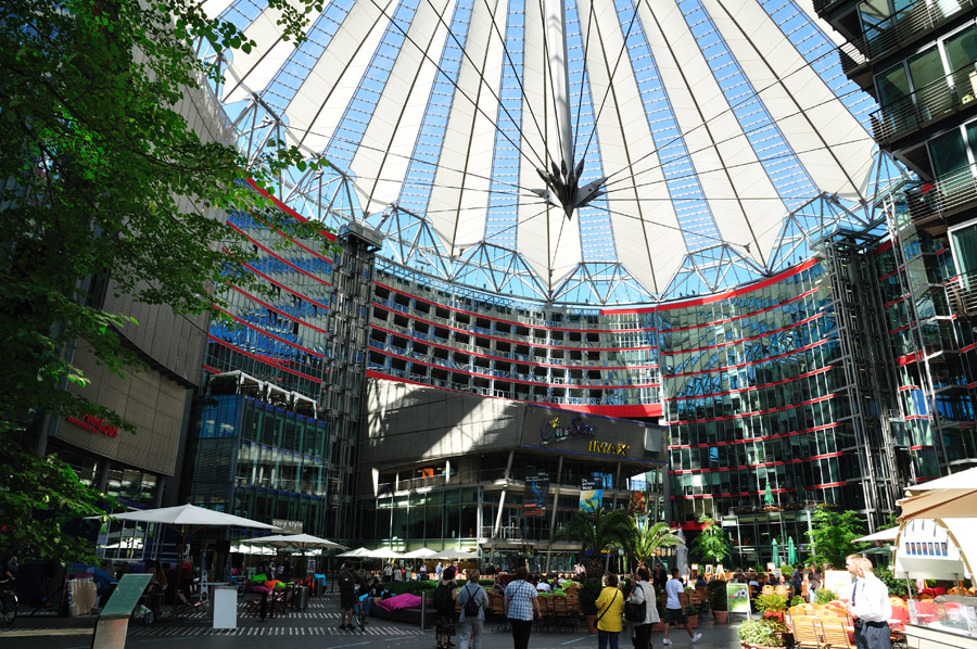
Many of the properties in the neighbourhood were the work of architect Georg Friedrich Heinrich Hitzig (1811–81), a pupil of Schinkel who also built the original "English Embassy" in Leipziger Platz, where the vast Wertheim department store would later stand, although Friedrichvorstadt's focal point and most notable building was the work of another architect—and another pupil of Schinkel. The Matthiaskirche (St. Matthew's Church), built in 1844-6, was an Italian Romanesque-style building in alternating bands of red and yellow brick, and designed by Friedrich August Stüler (1800–65). This church, one of fewer than half a dozen surviving pre-World War II buildings in the entire area, forms the centrepiece of today's Kulturforum (Cultural Forum).
Meanwhile, many of the Huguenots fleeing religious persecution in France, and their descendants, had also been living around the trading post and cultivating local fields. Noticing that traffic queues often built up at the Potsdam Gate due to delays in making the customs checks, these people had begun to offer coffee, bread, cakes and confectionery from their homes or from roadside stalls to travellers passing through, thus beginning the tradition of providing food and drink around the future Potsdamer Platz. In later years larger and more purpose-built establishments had begun to take their place, which in turn were superseded by even bigger and grander ones. The former district of quiet villas was by now anything but quiet: Potsdamer Platz had taken on an existence all its own whose sheer pace of life rivalled anything within the city.
By the mid-1860s direct taxation had made the customs wall redundant, and so in 1866–7 most of it was demolished along with all the city gates except two – the Brandenburg Gate and the Potsdam Gate. Though deprived of their function, Schinkel’s temples lived on for eight more decades. More significantly though, the removal of the customs wall allowed its former route to be turned into yet another road running through Potsdamer Platz, thus increasing still further the amount of traffic passing through. This road, both north and south of the platz, was named Königgrätzer Strasse after the Prussian victory over Austria at the Battle of Königgrätz on 3 July 1866, in the Austro-Prussian War.